Dr Richard Cuttler reports on a project to create a unique historical landscape record in the Arabian/Persian Gulf.
Archaeologists from the Department of Classics, Ancient History and Archaeology are collaborating with the Qatar Museums Authority to find new ways of mapping the marine areas of the Arabian/Persian Gulf. This is part of a larger project, which over the past six years has developed customised software for the recording of all sites, monuments and heritage information in Qatar, resulting in the first national heritage geospatial database for the region: the Qatar National Historic Environment Record (QNHER).
With sea levels more than 120 metres below present-day levels approximately 18,000 years ago, the Arabian/Persian Gulf was free of marine influence. As sea levels rose between 18,000 and 6,000 years ago this region became submerged and is now largely inaccessible to archaeologists. However, the applications of innovative mapping techniques are enabling us to understand the former landscape.
Using large-scale geophysical datasets for the archaeological purposes on a large-scale was pioneered by the University of Birmingham for the study of the palaeolandscape of the southern North Sea. The project employed advanced visualisation and computer techniques, to reveal a submerged Mesolithic landscape in unprecendented detail.
Within the marine areas of the Gulf extensive remotely sensed surveys are largely used for oil exploration and infrastructure development. Of particular interest to archaeological geophysicists is seismic reflection survey, which involves initiating a seismic energy source, usually a controlled acoustic signal, and collecting reflected data. By measuring the time taken for a wave to travel into the earth and for the reflection to arrive at a receiver it is possible to estimate the depth of the feature generating the reflection. From the reflected seismic waves it is possible to estimate the changes in the composition and properties of the sediments, and so map the landscape.
Analysis of digital bathymetric and 3D seismic data is showing that the former Gulf landscape was characterised by three lake basins, the largest of which would have been more than 22,000 square kilometres. The 3D seismic data also suggests that the former confluence of the Tigris and Euphrates Rivers would once have flowed into this landscape providing fresh water to the lakes.
It also suggests that another main feature of this landscape was a valley or alluvial plain that would have been up to 90 kms across. Analysis suggests that this river valley was relatively flat, and this region would more likely have been a contiguous area of lakes, marshland and converging channels, rather than simply a river valley. Much of the region is extremely dry and early populations would have welcomed the availability of constant fresh water.
By 8,000 years ago sea levels were approximately 13 metres lower than today, however significant areas of the southern Gulf remained as dry land. The Ubaid period in southern Mesopotamia around 8,000 years ago is characterised by large settlements, and some of the first public architecture. In the Gulf at 7,500 years ago we see the earliest evidence for stone-built buildings, but no evidence of earlier occupation. Given the distribution of archaeological sites, it would be reasonable to consider that some antecedents are now submerged within the marine areas of the Gulf.
Besides analysing data collected for the purposes of oil exploration the team have also begun the lengthy process of submerged landscape analysis in northwest Qatar, with a combination of side scan sonar, seabed sampling, and diving. From the 3D seismic and bathymetric data the team was able to target areas for high-resolution marine geophysics. The clarity of the data collection is such that images are very detailed, particularly in the case of man-made structures such as steel-hulled shipwrecks. Recently, the team added seven new shipwrecks to the Qatar National Historic Environment Record.
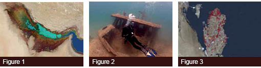
As each new wreck was discovered one marine archaeologist, one environmental specialist and a photographer/videographer dived to record each site. The extents of the visible structure, condition, construction materials, as well as any remaining gears or fittings were recorded along with the ship's dimensions. An initial series of sketches from various vantage points were created to form part of the on-going record of each wreck. During dives visibility was often restricted to a maximum of five metres, however, by using vertical photographs and mosaic software it was possible to record an entire image of each shipwreck (main image). Over time each shipwreck develops into a reef that becomes a thriving microcosm of marine life.
To appropriately record sites in Qatar some form of geospatial database was necessary. However, most software used for recording heritage data was unsuitable for the task. We developed a custom application. Based on a web server and accessed through a modern web browser, it is a truly bilingual system. The software is specifically designed to record all kinds of heritage data from both the terrestrial and the marine environments.
The software and data architecture was designed and developed by heritage data management specialists with extensive experience of cultural resource management. This provided a necessary understanding of the needs and challenges faced by the end users.
*The project is a collaboration between the Qatar Museums Authority and the University of Birmingham, with the support of H.E. Shaykha al-Mayassa bint Hamad bin Khalifa Ãl-Thãni (Chairperson of the Board of Trustees, Qatar Museums Authority) and H.E. Shaykh Hasan bin Mohammed Ãl-Thãni (Vice-Chairman of the Board of Trustees, Qatar Museums Authority). The project is Co-Directed by Faisal Al Naimi (Qatar Museums Authority), Richard Cuttler and Vince Gaffney (University of Birmingham).
- Figure 1: Extent of marine transgression around 14,000 years ago in dark blue, and the possible extent of the western and central lake basins in light blue
- Figure 2: University of Birmingham staff inspect and record a new shipwreck
- Figure 3: Main interface for the QNHER heritage management software