Dr Richard Cuttler reports on a project to create a unique historical landscape record in the Arabian/Persian Gulf.
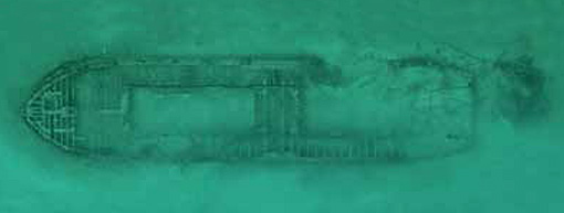
Archaeologists from the Department of Classics, Ancient History and Archaeology are collaborating with the Qatar Museums Authority to find new ways of mapping the marine areas of the Arabian/Persian Gulf. This is part of a larger project, which over the past six years has developed customised software for the recording of all sites, monuments and heritage information in Qatar, resulting in the first national heritage geospatial database for the region: the Qatar National Historic Environment Record (QNHER).