The Peart Collection

Maps and atlases in the School of Geography, Earth and Environmental Sciences. 

Colourful map from the Peart Collection

The Peart Collection comprises over 500,000 sheet maps, 2,000 atlases and a local history reference collection. Covering a comprehensive range of both official series mapping and commercially produced material, the collection represents the full range of physical and human disciplines, including administrative, political, historical, and commercial themes.

The collection provides resources for academic staff and research students to support the curricular and research activities of the School.

On occasion, we promote the collection by engaging in community activities and supporting university-wide initiatives, including Workplace Wellbeing Week and the Arts & Science Festival.

For queries relating to the Peart Collection contact Dr Phil Jones (p.i.jones@bham.ac.uk).

Outstanding features of the collection

  • 16th-20th century maps and engravings of Birmingham and the West Midlands region. 

Historic Birmingham map from the 18th century

  • Original early OS large-scale mapping of Birmingham and London.

Extract from early large scale OS map of central Birmingham

  • Most published editions of the OS 6-inch to 1-mile County Series maps of all six midland counties.
  • OS 1-inch to 1-mile mapping from unique early engravings through to present-day editions.
  • Early 1-inch to 1-mile OS maps of England overpainted with hand-tinted geological information.

Early hand tinted geology map showing Birmingham on the left

  • OS maps covering all published scales and themes, from 1900 to 2020.
  • Over 1,000 unpublished late 20th century large-scale plans of Japanese towns and cities.
  • Official series topographic mapping at varying scales of most European countries.
  • Official series mapping of many other countries, from Australia and Myanmar, to Peru and Antarctica.
  • 20th century mapping produced by The Department of Overseas Surveys and the Directorate of Colonial Surveys.
  • British and foreign atlases comprising over 2,000 volumes and including national official surveys and commercially produced volumes covering many themes.

The local collection

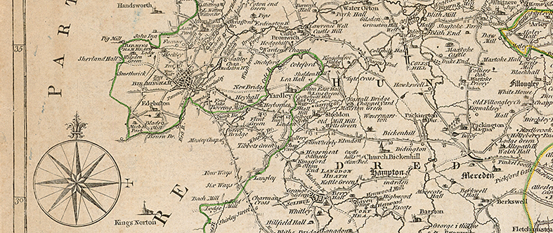
The Peart Collection holds an extensive selection of historic maps covering Birmingham and the West Midlands region. 

Pigott Smith map of Birmingham 1820s

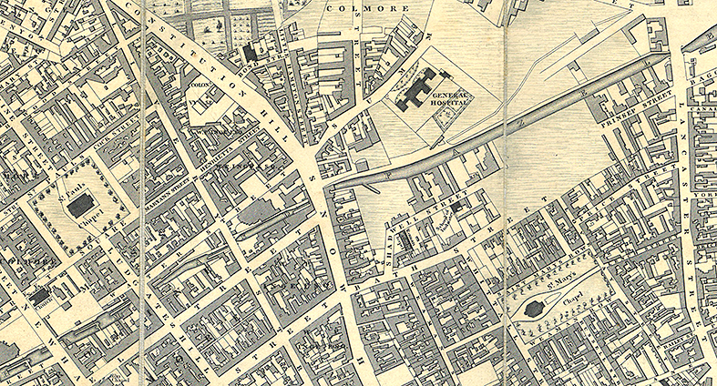
Beginning with original engravings of the Midlands counties dating from the early 17th century, the collection holds examples of most major maps produced from this time up to the establishment of the Ordnance Survey in the early nineteenth century. OS large-scale plans at 6-inch, 25-inch and 50-inch to 1-mile are available for Birmingham and its surroundings at various dates along with a selection of engravings of Birmingham scenes and buildings.

Birmingham panorama 1930s

The maps are accompanied by a collection of books, pamphlets, gazetteers, trade directories, town guides and handbooks relating to Birmingham and the Midlands area, with a particular emphasis upon the historical development of Birmingham.

Coming soon – we are working to scan parts of the local collection and aim to make the resources available online. 

1755 map of Warwickshire

Guide to digital resources

Many of the maps held by the Peart Collection are already available online. This is our guide to digital map resources.

Current and historic Ordnance Survey mapping is available through digimap https://digimap.edina.ac.uk/. Log in using your university credentials to access these resources.

1880s Ordnance Survey map of Central Birmingham

The UK deposit libraries all hold large collections of maps & all have some online access to their resources.

National Library of Scotland - https://maps.nls.uk/. Particularly useful for historic Ordnance Survey maps.

The British Library - https://www.bl.uk/subjects/maps#

University of Cambridge Map Library - https://www.lib.cam.ac.uk/collections/departments/maps

Bodleian Map Library - https://www.bodleian.ox.ac.uk/maps

Why the 'Peart Collection'

Jamie Peart was the Map Curator for Geography at Birmingham for close to four decades until his retirement in 2020. He maintained an active map acquisition policy, accepting donations from the Ministry of Defence Mapping Agency, various universities and government bodies, working tirelessly to ensure that the map collection grew and flourished. The Map Library has been renamed The Peart Collection in recognition of his contribution to keeping maps at the heart of the school.

Maps have long been acquired and used here at Birmingham and the collection has grown over time. In the seventies, the Head of Geography, Professor Harry Thorpe, used his wartime mapping background to acquire a large collection of superseded military mapping. This, along with generous gifts from philanthropists such as the Cadbury family formed the foundation of the collection which Mr Peart developed.

Society for the Diffusion of Useful Knowledge map of Birmingham