Professor Michail Antoniou
Chair in RF Sensing Systems
Profile of Dr Michail Antoniou, Electronic, Electrical and Systems Engineering, University of Birmingham

Synthetic Aperture Radar (SAR) is the primary method of obtaining fine resolution radar imagery. SAR and Inverse SAR (ISAR) are powerful sensing technologies that give the potential for imaging and azimuth/ cross-range resolution refinement, revolutionising the way we perceive the environment, be it automotive, maritime or space.

To obtain such imagery requires radar instrumentation, where either the transmitter and/or the receiver are mounted on a moving platform, typically airborne or spaceborne. The resulting images are similar to optical photographs in the sense that while optical images reveal how well a surface reflects light, a radar image records how well a surface reflects electro-magnetic energy.
Despite generally being of a lower resolution than an optical image, and requiring signal processing to form imagery, SAR instruments can see through obstructions such as clouds and smoke, as well as measure the dielectric properties of an object. They are thus indispensable tools for a range of applications in Earth Observation as well as defence and security.
At MISL, we are developing novel algorithms for SAR and ISAR processing, with the SENSYS group in particular having more than 15 years' experience on SAR research, from image formation techniques to the creation of technology demonstrators we regularly fly.
We are heavily involved in creating an agenda for SAR in the UK by co-chairing the SAR Focus Group of the Electro-Magnetic Systems Interest Group (EMSIG), and internationally as members of two NATO scientific panels and international collaborations. Some of our research highlights are summarised below.
Chair in RF Sensing Systems
Profile of Dr Michail Antoniou, Electronic, Electrical and Systems Engineering, University of Birmingham

Chair in RF and Space Sensing
Staff profile for Professor Marco Martorella.

Assistant Professor in Applied Signal Processing
Profile of Dr Christopher Gilliam, Electronic, Electrical and Systems Engineering, University of Birmingham

Hui-Lin Cheng Yaxuan Li

Joe Bryan
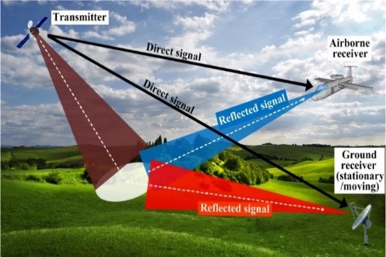
Using spatially separated transmitters and receivers for signal transmission and echo reception results in viewing the same target area from multiple viewpoints simultaneously. Images obtained from multiple distributed transmit/receive pairs can be combined to drastically enhance image information space, in multiple dimensions.
We have conducted pioneering research on distributed SAR systems, including transmitter-receiver synchronisation, distributed image formation, and image information extraction. Our system concepts, some of which were world-firsts, have been theoretically investigated and experimentally confirmed, with experimental demonstrators we built using existing illuminators of opportunity, and with support from EPSRC, DSTL, and ESA. Those have included a high-TRL demonstrator using multiple navigation satellite system transmissions (e.g. GPS) built in collaboration with industry (IFEN GmbH), and an airborne SAR demonstrator using digital television broadcasting signals.
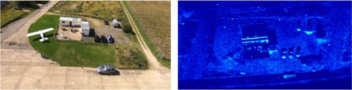
Drones are becoming prolific and can already carry a number of sensing payloads across the EM spectrum, for a rapidly increasing number of applications. These developments have been in parallel to the availability of compact yet powerful radar instruments at high frequencies, driven by global requirements for shorter range radar sensing.
The research being carried out within the SENSYS group at MISL concentrates on investigating the art of the possible in using drones equipped with compact radar imaging sensors. Those could be used for on-demand, rapid monitoring where visual human inspections are otherwise hazardous or impossible. With the main focus the creation of drone-based SAR systems, and their use for very high-resolution, multi-dimensional SAR images.
In terms of hardware, we have so far built two systems operating at 24 and 77 GHz, respectively.
In parallel, we are conducting research on novel image formation algorithms that compensate for the dynamic nature of drone flight. Those have been experimentally tested with our systems to provide resolution of up to approximately 2 cm.
One SAR based technique developed and patented by the researchers in MISL is Doppler beam sharpening (DBS), a form of unfocussed SAR, straightforwardly implemented on a range-Doppler map. DBS maps the measured Doppler frequency of a target to its angular position; thus, a wide real azimuth beam is sub-divided into smaller sub-beams.
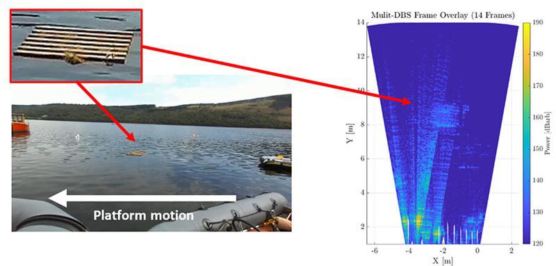
DBS has been successfully implemented in automotive and maritime environments using commercially available mm-wave automotive MIMO sensors and a sub-THz sensor suite developed at MISL.
By combining DBS with a traditional MIMO beamformer, high sidelobes due to equivalent one-way propagation effect of the MIMO beamformer have been significantly suppressed whilst improving the cross-range resolution. Additionally, the full structure of targets is also visible that is otherwise not identifiable with MIMO imagery.
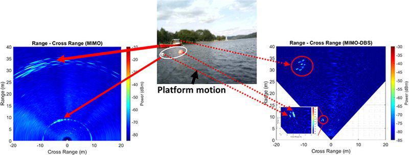
MIMO-DBS beamforming when combined with accurate estimates of platform dynamics (position, velocity, heading) is useful to locate and track targets in world coordinates. This will be particularly useful for scene reconstruction and path planning and is the current focus of this work.